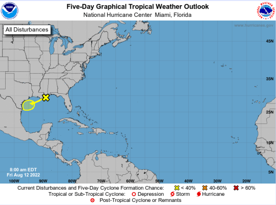
Trough in the Gulf of Mexico
Body
Trough axis and mid-level low pressure system over the northern Gulf of Mexico will drift westward over the weekend and into the lower TX coast.


Trough axis and mid-level low pressure system over the northern Gulf of Mexico will drift westward over the weekend and into the lower TX coast.
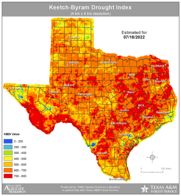
After months of drought and heat it finally appears that much of the area will see some relief this week as several factors combine to bring widespread rains to the area. Scattered showers and thunderstorms will again develop along the seabreeze today…these storms will have the potential to produce lightning induced fires (as seen yesterday over east Texas). Wednesday starts the same as today, but changes begin by afternoon as a decent shortwave in the developing eastern US trough digs southward over the MS valley.
Mid and upper-level ridge is centered over the southern plains this morning, but is just far enough inland that tropical moisture is sliding NW toward the TX coast. Radar shows scattered showers and thunderstorms across the offshore waters and a few have moved inland over the coastal counties this morning. As temperatures warm into the low to mid 90’s showers and thunderstorms will develop along the inland moving seabreeze boundary.
Saturday, July 23, is the 71st Annual Celebration and fundraiser for the Industry Volunteer Fire and Rescue.
It will be held at the Firemen's Park on Highway 159 in Industry, and Fried Chicken plates with all the trimming will be served from 5 to 7:30 p.m. for $15 per plate, dine-in or carry out. There will also be a variety of cakes and pies available.
According to the flier for the event, all donations and support will help to purchase firefighting equipment to better serve the community.
Upper level ridge of high pressure currently located over the SW US will back westward slightly today and weaken on the eastern flank. This will allow a trough over the southern US to move westward a bit. Local radars over LA this morning show a complex of thunderstorms east of the central LA area moving westward and convection allowing models (CAMs) are in general agreement that this complex and its associated outflow boundary will continue westward toward the Sabine River today and then into east Texas this afternoon and toward the I-45 corridor by mid to late afternoon.
An upper-level ridge of high pressure is building yet again over the southern plains, this time centered over OK and N TX where surface air temperatures will reach 108-113 degrees over the next few days. Locally SE TX is sitting at the base of the ridge and we will “only” see actual air temperatures in the low 100’s however heat index values will reach 107-112 during the afternoon hours which is good enough for another heat advisory that starts tomorrow and will likely last much of the week.
Christian City Fellowship on Highway 36 in Bellville will be hosting a Fourth of July event on Monday from 6 to 9 p.m.
There will be live music, free bomb pops, food trucks, inflatables, and fireworks.
For more information, visit www.ccf.life/july4
Free chili dogs and frito pies will be available from 11 a.m. to 2 p.m. Friday, July1, at Austin County State Bank Sealy branch for their Customer Appreciation Day for anyone who is ready to start celebrating Independence Day weekend a little early.
The Texas Department of Public Safety (DPS) Texas Highway Patrol (THP) will be initiating two traffic safety campaigns during the holiday weekend looking for people violating traffic laws from Friday, July 1, through Monday, July 4.