TxDOT preparing study for highway connection
SH 36, I-69 to potentially connect to US 290, SH 6
The Texas Department of Transportation (TxDOT) is preparing a study for a potential highway corridor connecting SH 36/I-69 southwest of Rosenberg northward to US 290/SH 6 north of Hempstead.
The purpose of the project is to (1) address anticipated mobility/congestion issues based on projected growth, (2) improve north/south freight movement, (3) improve north/south system linkage/ connectivity and (4) improve safety and increase hurricane evacuation route capacity within the study area and region.
Split of Proposed 36A Project
Pre-Notice of Intent (NOI) meetings have been held with multiple stakeholders in the Study Area, including Austin County, Fort Bend County, Harris County and Waller County, as well as with major landowners and public interest groups such as the Greater Fort Bend Economic Development Council and the Katy Prairie Conservancy. Through this public involvement, the project team received comments regarding the proposed purpose and need of the project and major development constraints to be considered. Further, stakeholders requested the project to be split into two segments with Interstate 10 dividing the southern and northern segments. In addition, stakeholders requested the southern terminus be extended further southwest to SH 36, south of Needville, increasing the overall 36A project length from 55 miles to approximately 65 miles.
While this proposal would separate the larger project into two separate segments of independent utility (SIU), the Houston district believes the integrity of the environmental analysis will not be compromised. As the SIU designation suggests, both projects can function independently to meet their individual purpose and need without the necessity of the other project. Environmental clearance under the National Environmental Policy Act (NEPA) for the proposed 36A corridor would be accomplished through preparation of separate EISs for each of these SIUs. The Houston district believes this separation will have the benefit of allowing each SIU to progress independent of the other, on their own schedules, and allow focus and flexibility in addressing the unique issues, concerns or constraints of each of the SIUs without compromising the integrity of the environmental analysis.
The I-10/US 90 corridor is proposed as logical termini between the southern and northern SIUs. The I-10/US 90 corridor meets FHWA’s guidance on the development of logical termini (FHWA 1993). FHWA’s guidance defines logical termini as: (1) rational end points for a transportation improvement, and (2) rational end points for a review of the environmental impacts. Additionally, I-10/US 90 is a major traffic generator.
Northern SIU Considerations
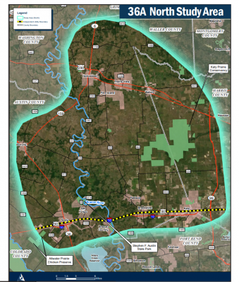
The proposed northern SIU would extend from the I-10/US 90 corridor northward to US 290/SH 6 north of the city of Hempstead, for a total of approximately 32 miles. This area is less developed than the southern segment and has somewhat different characteristics. Within the northern segment there are manufacturing, warehousing and industrial distribution facilities, retail/commercial developments, Houston Executive Airport, and proposed master planned communities. Areas of natural concern include prairie lands that are protected and managed by the Katy Prairie Conservancy, prime and unique farmlands, Stephen F. Austin State Park, potential of a Brazos River crossing or floodplain impacts, the headwaters of Cypress Creek, and potential riparian impacts.
Southern SIU Considerations
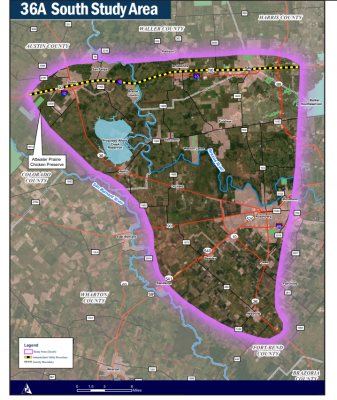
The proposed southern SIU would extend from SH 36 south of Needville (southwest of Rosenberg) northward to the I-10/US 90 corridor, for a total of approximately 33 miles. Although the original limits of the study began at I-69/US 59, coordination with county officials and H-GAC led to the conclusion that an extension of the southern terminus to south of Needville would better accommodate the growing traffic demands and safety needs of the area. The southern segment has experienced a high growth rate, and the project has strong support from elected/public officials. SH 36 south of Needville is currently being improved by TxDOT to provide improved emergency evacuation, enhance access to southern Brazoria County and improve freight mobility with Port Freeport. Within the southern segment there are rail intermodal yards, manufacturing, warehousing and industrial distribution facilities, retail/commercial developments and large master planned communities. Areas of natural concern include prime and unique farmlands, the Attwater Chicken Preserve, the proposed Allens Creek Reservoir, the potential of a Brazos River crossing, or floodplain impacts and potential riparian impacts.


